
As I was driving down one of Atlanta's many windy, one-way, lane-suddenly-becomes-a-turn-lane-only roads, I wondered: How has Google managed to map seemingly every route, trail, and backroad with such accuracy? It's a feat of immense scale, and I was skeptical that the solution was purely technical. AI still can't tell between a cat and guacamole, there was no way an algorithm would've been able to interpret pure visual data with such accuracy.
So, I thought I'd do some research into how Google Maps managed to become the superpower app it is today. Turns out: it was never just an engineering feat at all.
Google Maps has more than a billion users every month. It's indispensable for helping people get places, wherever in the world that may be. Google, being primarily in the business of organizing data, first began development on Google Maps in 2005 with data sources ranging from public map data to acquired satellite startups [1, 2]. This was not nearly enough to map an entire state, let alone a country. So, Google decided to map the US themselves. They began Google Street view, getting real people to drive around with huge cameras. It's estimated Google Street view drivers drove a total of around 7 million miles [2].
According to Reddit forums and job reviews, it's a very secretive role. Google doesn't make it easy to know how to get the job. The first few years of the program, it's reported that they would have drivers drive around their own cars (providing just the cameras) for a little over minimum wage. It was a somewhat flexible job, and drivers report being proud of having contributed to a feat of such scale. Pay also reportedly differed between rural and urban areas, though. The most recent reports show an average wage of $11-15 per hour, close to a living wage. Although the job wasn't quite like this College Humor video makes it out to be, drivers report facing some level of risk as the car attracted local attention on its way [2, 3, 4, 5, 6, 7].
Google compiled the Street View data, and then made a few company acquisitions for satellite data, but just having the data wasn't enough. It needed to be processed into accurate maps, and AI at the time (early 2010's) couldn't do it with complete accuracy. That's when the Ground Truth Project was developed. This project aimed to turn all the data Google had into accurate routes that Google Maps could run on. The project was partly engineering work, to build an interface that would allow for editing the routes, and part manual labor, with a secretive team called Atlas that manually pored through all of the map views and meticulously updated the predicted routes to match the actual roads. The engineering tool was internally made, and Atlas was a supposedly "heavily-trained" workforce of an estimated hundreds of people, but Google hasn’t shared about how many people actually worked on editing the maps [2, 8].
Atlas workers were Google employees meant to review and correct roads, but that wasn't enough to cover routing the entire world. Google then launched the Map Maker program, so that individuals could report and correct map issues themselves. This was essentially volunteer-based labor to correct Google Maps and in certain parts of the world, actually gather the data to create the maps.
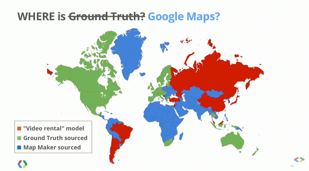
The map above shows exactly where the Ground Truth/Atlas project was used to create Google Maps, versus where Map Maker was utilized. Map Maker was utilized in large swathes of the world, where driving conditions are not as clear or map data is otherwise harder to procure, which insinuates that Google Maps built their service for almost half the world with the free labor provided by volunteers there. The countries in red on the map are supposedly the countries that do not allow free labor for commercial applications, which is what Google Maps is [8].
Outside of the huge amounts of (paid and unpaid) labor that went into making Google Maps, location data is also harvested that goes back into improving the service. They never explicitly share how they utilize this data, but it's used for much more than just routing you to your destination. It is claimed that Google uses location data for features like showing users traffic levels and the amount of crowds at locations, but an interview with a Google PM shows that they're secretive about all the applications: ''’Google uses location in multiple ways, but there's nothing specific I can talk about beyond that,’ he said." [7]. They say the data is anonymized, but there's no way to opt-out of this use of your location. An old Google blog claimed that there was an opt-out form, but the link is now broken. Past just being utilized for the Google Maps app, your data is being shared across all Google services. According to their privacy policy, "Location History and Location Reporting data may be used by any Google app or service". You're not sending your location to just Google Maps, but also to Youtube, Google Search, Adsense, the list goes on.
Google Maps is a crucial service for most people's day to day, and the fact that it's free for everyone makes it, dare I say, a great public utility. I found it intriguing, though, how Google poses itself as a pure-tech company, when so much manual labor has to go into making a single app like Google Maps. Google Maps is reported to generate up to $5 billion in revenue a year, and they were able to develop such an accurate service with free labor that volunteers were not compensated for, not to mention the location data Google harvests and profits from. It is not clear to Google Maps users exactly how their location is being utilized, which is another safety and privacy concern Google & Google Maps should address (although, as we’ve seen before, they hesitate to do so).
Maybe it isn’t possible to build a product of the scale and accuracy of Google Maps without crowdsourced input. Google Maps is truly a feat of modern technology, and maybe without the volunteers, paid workers, and street view drivers, billions of people wouldn't have the service today. But, the hidden nature of how Google Maps was built makes clear the underlying incentives for Google. At the end of the day, Google is profiting off of the free product, and the profit came off many, many hours of not just paid workers, but volunteers, who donated their time and energy to provide a service that's essential to all of us.
My take: I don't love that Google used all of that volunteer time to build up their service, though I do see that it has helped many users get more accurate mapping. Ideally Google would be more forthcoming about the amount of profit it generates from Google Maps, in addition to exactly how much volunteer time was used, and how our location data is utilized within (and outside of) the service.
P.S. If you're looking for more privacy friendly alternatives to Google Maps, check out this great list by Wired.
---------------------------------------------------------------------------
Sources
[1] https://en.wikipedia.org/wiki/Google_Maps#Mobile_app
[2] https://www.wired.com/2014/12/google-maps-ground-truth/
[3] https://www.glassdoor.com/Hourly-Pay/Google-Street-View-Driver-Hourly-Pay-E9079_D_KO7,25.htm
[4] https://www.indeed.com/cmp/Google/reviews?fcountry=ALL&fjobtitle=Driver
[5] https://www.quora.com/How-much-is-a-Google-Street-View-Car-driver-paid
[6] https://medium.com/message/an-interview-with-a-google-street-view-driver-240d067a7545
[7] https://www.reddit.com/r/IAmA/comments/2b33cu/iama_google_streetview_driver_ama/
[8] https://www.youtube.com/watch?v=FsbLEtS0uls&ab_channel=GoogleDeveloper


